Land Use Planning
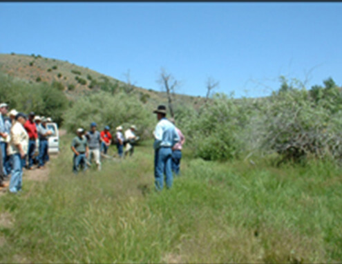
Brundage Mountain Land Exchange, Idaho
Under third-party contract with the Payette National Forest and Brundage Mountain Company in Idaho, Cirrus completed NEPA analysis on a proposed land exchange involving 476 acres of federal land at the ski area’s base exchanged for two private parcels, Reed Ranch and Squaw Meadows. The property at the ski area included most of the base-area infrastructure (e.g., parking, lodge, shop facilities, lift base terminals, etc.) and was slated for further commercial and residential development under the ski area’s master development plan. The private, 190-acre Reed Ranch parcel was of interest to the agency because it includes spawning habitat for federally listed salmon species on the South Fork Salmon River and a backcountry airstrip. The Squaw Meadows parcel was of interest because it includes a unique, high-quality, riverine wetland on the North Fork Payette River.
Cirrus's scope of work included all phases of the NEPA process, from the initial public notice that the process was being initiated through preparation of the Decision Notice/Finding of No Significant Impact and the administrative record. The full range of physical, biological, and socioeconomic impacts was assessed and documented in an Environmental Assessment (EA), analyzing in detail the potential direct, indirect, and cumulative effects of the proposed action and alternatives in regard to the following issues raised through scoping and internal review:
- Brundage
- Public Safety
- Recreation and Land Use
- Socioeconomics
- Wetlands and Water Quality
- Wildlife (including special status species)
Cirrus drafted and implemented a public involvement plan, including: drafting of legal notices and press releases; conducting public and agency scoping and analysis of scoping comments; and soliciting formal comment then analyzing and responding to formal comments. We assisted the agency in determining the list of substantive issues to be addressed, finalizing the proposed action, and developing alternatives. We managed an interdisciplinary team of direct-hire employees and subcontractors to complete the technical analysis documented in the EA and project record. We completed all GIS-based analysis and mapping required in preparation of the EAs. We wrote and produced the EA itself then compiled and indexed the administrative record. We assisted the agency in drafting the Decision Notice/Finding of No Significant Impact.
Cirrus also prepared a Biological Assessment documenting the potential effects of the proposed action on federally listed plant and animal species. Snake River spring/summer Chinook salmon, Snake River Basin steelhead, bull trout, westslope cutthroat trout, Canada lynx, gray wolf, and bald eagle were the primary special-status species addressed. This Biological Assessment was carried into consultation under Section 7 of the Endangered Species Act, and the U.S. Fish and Wildlife Service concurred with its findings in their Biological Opinion. We also prepared a Biological Evaluation addressing impacts on Forest Service sensitive species and Management Indicator Species.
The agency’s decision was not appealed or litigated, and the exchange occurred in accordance with the schedule, as modified by the agency through the course of the project. The project began in 2004 and was completed in 16 months.
Rich County Rangeland Resource Plan, Utah
Under contract with the Coordinated Resource Management (CRM) Committee in Rich County, Utah, Cirrus assisted in the development of a management plan for rangeland resources countywide, administered by the Forest Service, BLM, state, and private landowners. The CRM Committee consists of land owners; federal, state, and local government representatives; conservation groups; environmental groups; and other stakeholders. We then assisted the BLM with the NEPA process for the amendment of the agency’s Management Framework Plan to incorporate changes resulting from the CRM effort.
Facilitating the development of the CRM plan involved participating in a series of meetings with the CRM Committee and their Planning Subcommittee, summarizing discussions, and updating drafts of the plan. The plan was driven by four vision statements mandating: (1) rich, healthy ecosystems; (2) sustainable agricultural industry; (3) diverse recreational opportunities; and (4) vibrant rural economy. The plan described management goals, objectives, and actions/methods for each vision statement. Goals and objectives associated with each vision statement reflected issues identified through public and agency scoping efforts. The Planning Subcommittee created planned actions/methods for each vision statement to provide a “toolbox” from which situation- or issue-specific implementation plans could draw.
The BLM NEPA analysis addressed resource uses including: livestock management, mineral and energy development, lands and realty development, special designations, and Native American concerns.Identified resource impacts were in the areas of:
- Cultural Resources
- Fisheries Resources
- Rangeland Resources
- Socioeconomics
- Watershed Resources
- Wildlife Resources
We used GIS to facilitate landscape-level natural resource planning and management using spatial analysis of biotic and abiotic resources as well as land use and demographic patterns in the planning area. Various GIS data was analyzed to determine site selection of future habitat treatments and water resource protection measures and to assess impacts on habitat types, water quality, and wildlife populations.
The project began in 2003, and our role was completed in May 2006 when we submitted a draft Environmental Assessment to the BLM for their use in amending the Management Framework Plan.
PacifiCorp Site Plans, Idaho
PacifiCorp has contracted Cirrus to develop Site Plans for land and resource management at its five Bear River hydroelectric developments and to provide a range of diverse environmental support services on an as-needed basis. The Site Plans are completed in accordance with the Settlement Agreement and FERC license for the Bear River Hydroelectric Project and with PacifiCorp’s Environmental Management System (EMS). They insure that land use is ecologically sound and coordinated with power-generation operations on PacifiCorp owned lands. The planning effort is guided by PacifiCorp and an Environmental Coordinating Committee made up of regulatory and land management agencies and other stakeholder representatives. The plans identify and address resource conflicts in the following areas of:
- Agricultural Uses
- Public Access and Recreation
- Riparian and Wetland Habitat Management
- Vegetation Management
The planning process involves establishing and documenting the legal and procedural requirements for the Site Plans, developing desired future conditions, describing current conditions and existing environmental conflicts, devising effective plans to address these conflicts, completing a schedule for implementation of each plan element, and designing a program to monitor both compliance with the implementation schedule and effectiveness in meeting desired future conditions. The resulting Site Plans document each of these steps. We also complete all GIS-based analysis and mapping required in preparation of the Site Plans.
A Site Plan for the Grace-Cove development was completed in 2006, and a plan for the Oneida development will be submitted in 2007. Planning for the Alexander development will begin in 2007, for the Grace Dam development in 2008, and for the Last Chance development in 2009. The completed Site Plan met all requirements of the FERC license and the Environmental Coordinating Committee. All other regulatory mandates (e.g., Endangered Species Act, Section 404 of the Clean Water Act, and various state regulations) were also met.
Other environmental support services provided by Cirrus have included an assessment of the environmental effects of dredging a channel in the bed of Bear Lake to allow low-water operations of the Lifton Pump Station, completed in January 2002 and used to secure Corps of Engineers permitting for the project. Key issues addressed included potential effects on:
- Aesthetics
- Air Quality and Noise
- Economics
- Fish and Other Aquatic Organisms
- Lake Levels
- Navigation and Safety
- Vegetation
- Water Quality
- Wetlands
- Wildlife